Sunday, September 28, 2008

Silver Comet Grand Opening Photos


The sun had not yet cleared the horizon, but it was just getting light enough to get a feel for how many cyclists would ride 61.5 miles -- the entire length of the Silver Comet Trail -- to the Alabama border. I was impressed so many people would get up early on a Ssturday to join us before dawn, but then again, some of those present had waited 10 years, since the first segment of the trail had opened near Hiram in 1998.

Hundreds more would join us along the way.

At first, the pace was leisurely. In the cool air, it was taking a while for the legs to warm up, but soon the sun started peeking through the trees and several riders started to push the pace. Before long, everyone had found a partner (or several) who matched their pace. Michael and I sought out a group on the slower side. Unlike most, we planned a return trip by bike -- 125 miles for the day.

The last section of trail -- just completed in August -- was markedly different from the rest of the trail. It was a stretch between Rockmart and Cedartown where the trail left the rail bed and found a few hills. The hills weren't long, but they were steep. All the bike-walking and cramping occurred in this stretch, but it also afforded some fine views of the surrounding hills.

We plan to make a return visit by bike to Rockmart. The trail by the river, foot bridges, downtown square, Frankie's Italian Restaurant, and the Nathan Dean Sports Complex make Rockmart a great destination for cyclists. I should have visited years ago.

The highlight of the festival at the border was a "ribbon-joining" ceremony. (YouTube video of ceremony courtesy of kjfitzgerald593) Kids from Georgia lined up on the Georgia side. Kids from Alabama lined up on the Alabama side. They carried ribbons across the line and officially joined the Silver Comet with the Chief Ladiga trail. 95 miles of continuous trail.

Riding back with Michael and I were a few other hardy souls. John missed out on the barbecue sandwich and talked about food the whole way back. Anything that smelled remotely like food, grilling, or even fire got him going. Exercise suppresses my hunger, but listening to him talk about Atlantic Salmon dinners, his Aunt's black-eyed pea salad and plates of spaghetti was enticing to me. It was nice to be yearning for something you knew was going to be satisfied soon.

So Michael and I completed 125 miles in one day. They were flat and cushy miles, but the miles did their job. The endorphins had me happy and relaxed for hours.

Thanks to everyone who joined us on the ride. Sorry we missed those who were not able to ride.

Labels:

Thursday, September 25, 2008

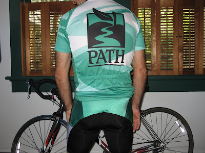
Sneak Peek at PATH kit


Saturday, in this kit, I'll be riding to the Alabama line and back as part of the Grand Opening of the the longest trail in America, the Silver Comet Trail. PATH created the kit specifically for this historic event which deserves a sharp kit (and probably a sharper model).

A few fellow Atlanta riders will be joining us (see the comments on this post).

I think this is going to be big. People I've never met ask me about details. I point them to this PDF from PATH's website.

We'll be the first group ride on the completed trail. Hope you can join us.


Posted by Picasa

Labels:

Wednesday, September 10, 2008

Longest Paved Trail in the US

 
The last foot of the Silver Comet Trail was poured on Aug. 29 making this 95.5 mile-long trail the longest in the US. On Sept. 27, the PATH Foundation is holding the Grand Opening of the trail.

I'll be riding with a group of cyclists that will cover the entire length of the trail within Georgia, taking us from just outside of Atlanta all the way to the border with Alabama. From there, the trail continues for another 35 miles to Anniston, AL. The celebration will occur at the state border.

The group ride leaves the Mavell Road access point at 7:30 AM on Saturday, June 27 and will be meeting riders from Alabama at the border with Georgia. Further details are posted in this PDF.

Commute Summary


Round Trip Distance: 18.7
Number of Cyclists seen: 35 (16 inbound, 19 outbound)
In-bound Route: Lullwater/PATH trail with extensions
Out-bound Route: Emory via Clifton
Weather: overcast and humid in morning, sunny and breezy in afternoon
Posted by Picasa

Labels:

Sunday, March 02, 2008

Variety is the Spice of Cycling

Jack took us on a different route today. After riding in this town for nearly 30 years now, I'm still fascinated by the number of good riding roads I've never ridden.

I would love to have a picture for you, but I'll have to get you to imagine a sunny warm day with crisp shadows of pines dancing across a winding, rolling road with no traffic. Imagine an historic covered bridge, a single lane wide, 7 foot height restriction (don't stand up), and wooden planks for the wheels to ride on. Then imagine this bridge crosses a rocky stream nearly hidden by the trees about 40 feet below. That was our ride destination today.

We paid for the scenery however. The most direct route to the covered bridge takes you across a sharp ridge on the west side of the Chattahoochee River. You can pick between a lot of climbing stretched out over a mile or a lot of climbing stretched out over a third of a mile. We picked the "gradual" route up Veterans Parkway, but we still came through the neighborhood with no one outdoors that I wrote about last November.

Ride Summary


Distance: 49.7
Number of Cyclists seen: Mass quantities
Route: Six Flags with an extension over to Covered Bridge and Silver Comet (thank you Jack for the route, I wish I brought a camera)
Weather: Blessed sunlight -- everyone we met was in a good mood because of the weather

Labels: ,

Friday, November 23, 2007

Long Ride - Fall Version


The Friday after Thanksgiving is always a good day for a long ride away from the malls. The Silver Comet Trail allowed me to put sufficient distance between myself and distracted drivers.


I wanted to explore a different route across I-285 to get to the Silver Comet. I chose a route that took me into a neighborhood that I knew was hilly. I just didn't imagine it would be granny-gear hilly for so many hills. There were several 100-200m stretches of >15% grade. Of course I got turned around and had to go up and down more than I bargained for. Particular painful were the stop signs at the bottom of the hill. I won't recommend this route.

Besides the hills, what I found striking about that neighborhood was no one was outdoors. I saw four people. All of them were getting in their car. How well could these people know their neighbors? It felt colder than the temperature.

I had wanted to ride at least 60 miles which would have taken me past Hiram. I would go out and see what kind of time I was making against the wind. I reached Dallas, GA after milepost 19, and realized I was only 3.5 miles from the Pumpkinvine Creek Trestle. This trestle was the highest point above the ground and would have an expansive view. I was ready for more miles.

I was surprised to find so much housing in view of the trestle. This was disappointing because the developer was the "trees must go" sort of developer. I guess we don't have to go far to find 3rd-world deforestation. The trestle was still nice.

At this point, I was within striking distance of the Brushy Mountain Tunnel at milepost 31 even though this would take my ride beyond 90 miles for the day. I had not seen the tunnel and I still felt good, so I rode on.

Beyond milepost 27 or so, the trail enters a State Wildlife Management area and the terrain becomes noticeably more contorted. The trail stays at an even grade while the land rises and falls above and below the trail. You'll be riding through a cut in the rock and then 2-3 hundred meters further you're looking down into a deep ravine. This was worth riding 80-90 miles to see. Not even a video would do this justice.


The Brushy Mountain Tunnel is bigger than I imagined. There is room for two lanes of traffic inside and tall vehicles that would have trouble with interstate overpasses would have no height problem in the tunnel.

The outbound headwind did not switch directions for my ride back in, and I had an easy time raising my average speed although I wasn't working as hard. As I came back into Smyrna, I found that I was able to clearly see Stone Mountain about 25-30 miles distant. Days that clear are getting fewer and fewer in Atlanta.
Posted by Picasa

Labels: , , ,